

How Mumbai Was Formed from Seven Islands – Real History Explained)
Mumbai’s geography is not just a matter of the past—it actively shapes the city’s present. Issues like flooding, uneven terrain, and coastal vulnerability are directly linked to how the city was formed. While it is commonly said that “Mumbai was made from seven islands,” this statement is often repeated without context. To understand Mumbai properly, one must go beyond the phrase and examine how these islands functioned, why they were merged, and what consequences followed.
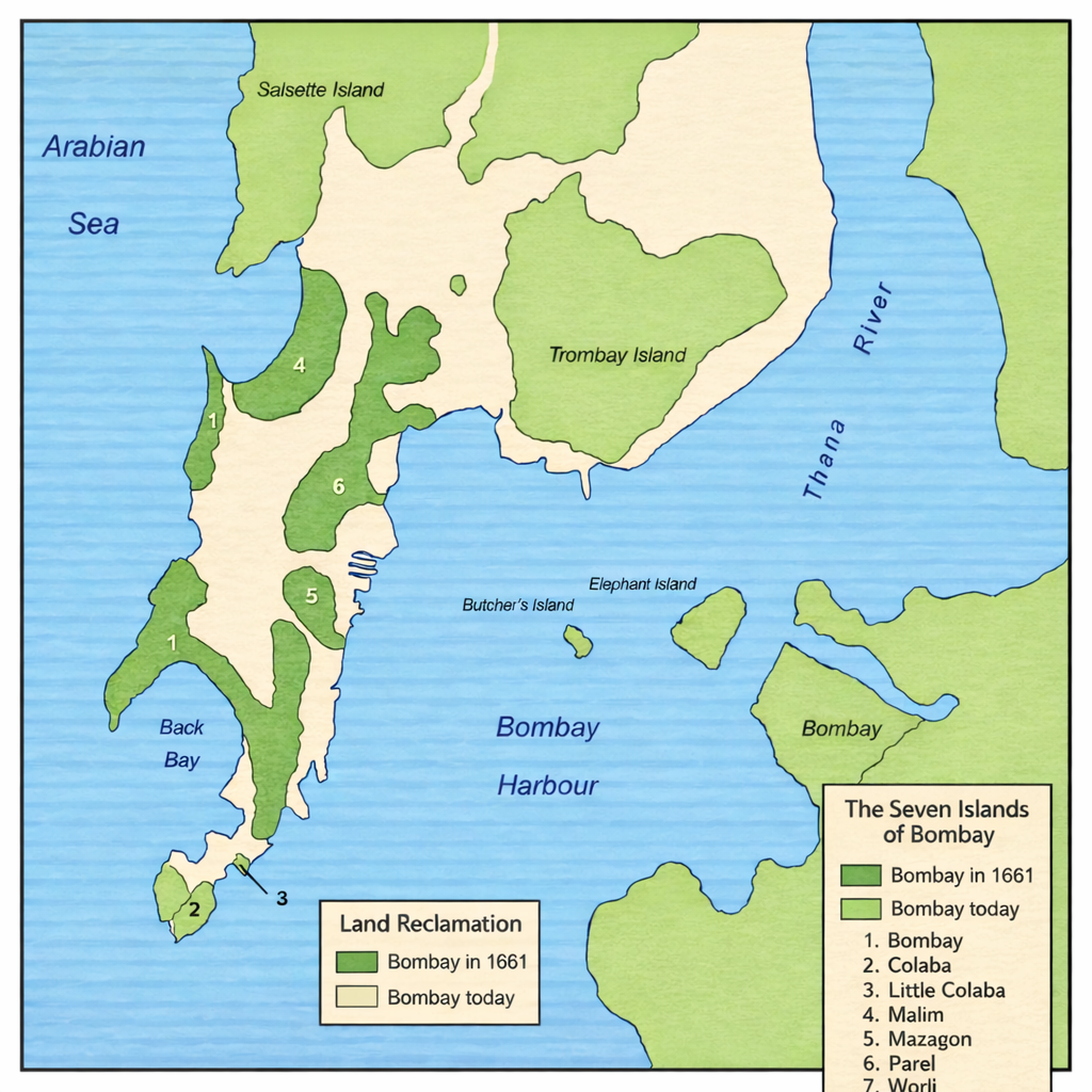
Distinction between Seven Island and Salsette island:
The term ‘Mumbai formed from seven islands’ applies only to the historic core of the city (present-day South Mumbai). The suburban regions—from Bandra to Dahisar—were never part of these islands. They belong to Salsette Island, a separate and much larger landmass that was later integrated into Bombay through administrative expansion and urban growth.
The Original Geography: Not One City, But Seven Separate Lands
What we now recognize as Mumbai was originally a fragmented coastal region made up of seven distinct islands. These were:
- Bombay Island
- Colaba
- Little Colaba (Old Woman’s Island)
- Mazagaon
- Parel
- Worli
- Mahim
These islands were not tightly clustered pieces of land. Instead, they were separated by creeks, marshes, and tidal flats that would regularly be submerged during high tide. Movement between them was difficult and often dependent on tidal conditions. In practical terms, this meant that the region functioned less like a city and more like a loosely connected maritime landscape.
Historical records such as the Imperial Gazetteer of India (1909) describe Bombay as a group of low-lying islands intersected by water channels, reinforcing the idea that natural conditions were a major constraint on development.
Early Phases: Indigenous Life and Portuguese Influence
Before colonial powers arrived, the islands were inhabited primarily by Koli fishing communities. Their lifestyle was closely tied to the sea, and the tidal nature of the land was not a limitation but a way of life. Even today, traces of these early settlements remain visible in parts of Mumbai.
The Portuguese took control of the islands in 1534 through the Treaty of Bassein. Their presence introduced churches, forts, and new cultural influences, but they did not attempt to alter the geography significantly. Their interest lay in religious expansion and maritime control rather than urban development.
British Control: When Geography Became a Problem to Solve
A decisive shift occurred when the islands passed into British control in 1661 as part of the marriage alliance between Charles II of England and Catherine of Braganza. Soon after, the British East India Company took charge and began to view Bombay not as scattered land, but as a strategic opportunity.
The natural harbor was one of the finest on the western coast of India, making it ideal for trade and naval activity. However, the fragmented geography posed serious challenges. Flooding, poor connectivity, and limited usable land made it difficult to develop Bombay into a major port.
At this point, the British approach differed fundamentally from the Portuguese. Instead of adapting to the geography, they chose to change it.
The Transformation: Engineering the Land Itself
The merging of the seven islands was not a single project but a series of engineering interventions carried out over decades. These projects aimed to control the sea, reduce flooding, and create continuous land suitable for urban expansion.
One of the most significant efforts was the Hornby Vellard project, initiated in the late 18th century. It involved constructing embankments to block seawater from entering low-lying areas between Worli and Bombay Island. This drastically reduced tidal flooding and made further development possible.
Alongside this, several causeways were built to physically connect the islands:
- The Sion Causeway (1803) linked Bombay to the mainland
- The Colaba Causeway (1838) connected the southern islands
- The Mahim Causeway (1845) linked Bombay to Salsette island.
- Additional reclamation filled marshes and sealed creeks
Over time, these efforts transformed the region from a collection of islands into a single, continuous landmass. By the mid-19th century, Bombay had effectively taken the shape we recognize today.
The Land Is Still Not Natural
A critical point often overlooked is that Mumbai is still, to a large extent, an artificial construct. The land may appear stable, but its origins remain in reclaimed marshes and filled creeks.
This has long-term implications. Areas that were once natural drainage channels no longer function as such, leading to water accumulation during heavy rains. Similarly, the low elevation of reclaimed land makes it vulnerable to tidal influence and sea-level rise.
This is why modern Mumbai experiences recurring challenges such as:
- Waterlogging during monsoon
- Flooding in low-lying reclaimed zones
- Stress on drainage and infrastructure systems
These are not isolated urban issues—they are consequences of historical decisions.
A City Built by Design, Not Just Growth
Mumbai did not simply grow over time; it was deliberately constructed through a combination of geography, necessity, and engineering. The merging of the seven islands allowed it to emerge as a major port and eventually as India’s financial capital. At the same time, this transformation introduced structural vulnerabilities that continue to affect the city.
Understanding Mumbai’s origin in this way shifts the narrative. It is no longer just a historical fact to remember, but a framework to interpret the city’s present and future.


: The Strategic Link That Enabled Bombay’s Northward Expansion")


[…] Also read: How Mumbai Was Formed from Seven Islands […]
Comments are closed.